by Ralf Tenbrink | 28, Apr 2026 | Bike Tours, Costa Blanca News, Self-Guided Cycling Tours in Costa Blanca
Self-Guided Cycling Tours in Costa Blanca: Your Complete Guide
Key Takeaways
| Feature |
Details |
| Duration |
6-8 days typical |
| Distance |
48-116 km per day |
| Best Time |
Year-round (325+ sunny days) |
| Starting Points |
Calpe, Alicante, Finestrat, Altea |
| Key Climbs |
Coll de Rates, Port de Confrides, Alto de Aitana |
| Price Range |
From €1,270-€1,400 per person |
| Difficulty |
Moderate to challenging |
| Bike Types |
Road, hybrid, e-bikes available |
Costa Blanca Self-Guided Cycling: What Makes It Special
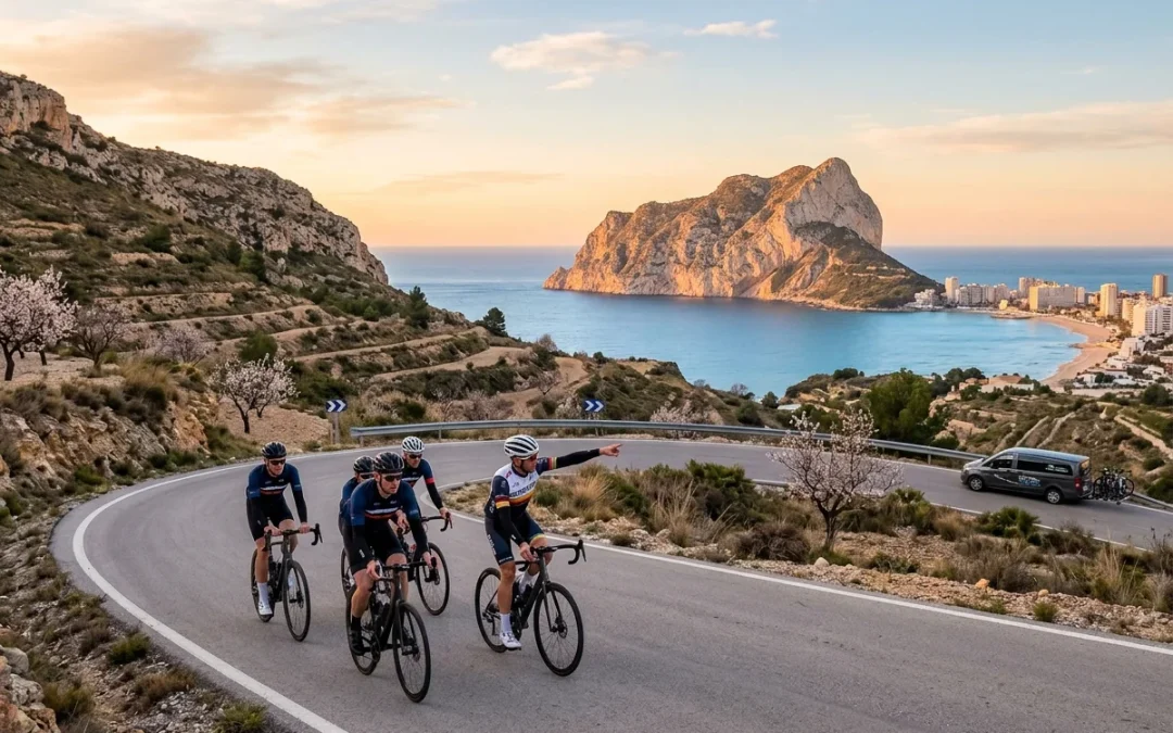
Why do so many cyclists choose Costa Blanca for self-guided tours? The answer lies in its perfect combination of challenging climbs, reliable weather, and stunning scenery.
This Spanish coastal region offers something unique – you get proper mountain passes just minutes from Mediterranean beaches. The climbs here aren’t just pretty rides either. Professional teams use these roads for winter training camps because the gradients and distances mirror what they face in major tours.
Take Coll de Rates, for instance. This Category 2 climb stretches 6.5 kilometres at 5% average gradient. It’s the same type of challenge you’d find in the Tour de France, but without the crowds and with sea views at the top. The road surface is excellent, traffic is light, and the scenery changes from coastal plains to mountain forests as you climb.
What really sets Costa Blanca apart is the variety within short distances. You can start your morning with a coffee in a fishing village like Altea, climb through almond groves and pine forests, then finish with lunch overlooking the Mediterranean. Few cycling destinations offer such dramatic landscape changes in a single ride.
The infrastructure supports self-guided touring perfectly. Roads are well-maintained, routes are clearly marked, and bike rental services provide quality equipment. You don’t need a support vehicle or guide – the region is set up for independent cyclists who want freedom to explore at their own pace.
Local cycling culture is strong too. Every Tuesday and Thursday, free group rides leave from cafés like Caffee Cadanz. Even on self-guided tours, you’ll encounter other cyclists who understand the routes and can offer local tips.
Planning Your Self-Guided Tour: Best Starting Locations
Where you start your tour shapes the entire experience. Each base town offers different advantages and access to specific route networks.
Calpe stands out as the most popular starting point. This coastal town sits perfectly between the sea and the Sierra de Bernia mountains. From Calpe, you can access Coll de Rates within 20 kilometres, or head inland toward the more challenging Port de Confrides. The town has excellent cycling infrastructure, with multiple bike shops and rental services. Accommodation ranges from budget hostels to luxury hotels, many specifically catering to cyclists.
Finestrat offers a different perspective. Located slightly inland near Benidorm, it provides quick access to some of Costa Blanca’s toughest climbs. The Alto de Aitana route starts practically from your hotel door. This base works well if you prefer fewer coastal distractions and want to focus purely on mountain riding.
Alicante makes sense for longer tours. As the regional capital, it has the best transport links and widest choice of services. The Alicante to Calpe route provides an excellent introduction to the region’s varied terrain. Starting here also lets you experience both urban cycling and rural mountain roads.
Altea combines the best of both worlds. This picturesque hilltop town offers stunning views and easy access to coastal routes like the Altea Hills Loop. It’s quieter than Calpe but still has good cycling facilities.
Consider your priorities when choosing a base. Want maximum climb variety? Choose Calpe. Prefer serious mountain training? Finestrat delivers. Need urban amenities and transport links? Alicante provides everything you need.
Essential Routes and Mountain Passes You Must Ride
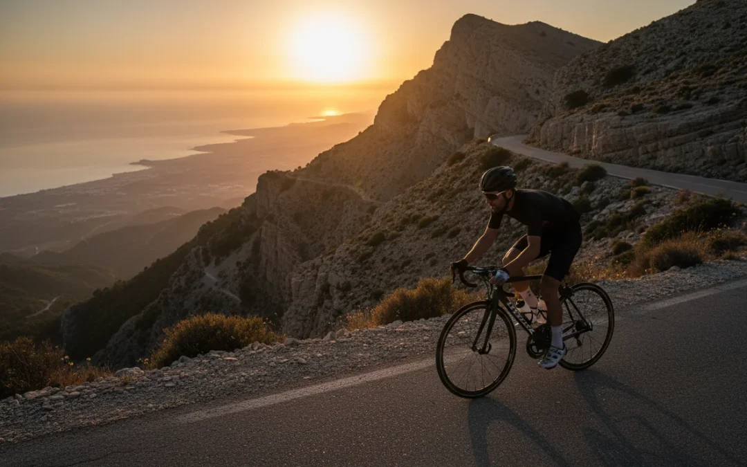
Costa Blanca’s mountain passes define any serious cycling tour. These aren’t gentle hills – they’re proper climbs that test your legs and reward you with spectacular views.
Coll de Rates is the region’s signature climb. At 6.5 kilometres with 5% average gradient, it’s perfectly pitched for most cyclists. The road winds through pine forests with glimpses of the Mediterranean below. Professional teams use this climb regularly because it mimics the length and gradient of Grand Tour mountain stages. The descent is equally enjoyable, with smooth tarmac and sweeping corners.
Port de Confrides presents a different challenge. This winding ascent through the Sierra de Serrella reaches higher altitudes and offers more technical climbing. The gradients vary considerably, keeping you guessing throughout the ascent. Views from the top encompass the entire Costa Blanca region.
Port d’Ebo combined with Coll de Rates creates one of the region’s most demanding circuits at 116 kilometres. This route includes sections up to 17% gradient on Pla de Petracos. It’s a proper test of climbing ability, but the rewards are proportional to the effort.
Alto de Aitana features in the 2026 Vuelta a España route, which tells you everything about its quality. This climb reaches the highest peaks in the region and offers 360-degree views from the summit. The Vuelta 2026 Stage 9 route follows roads that any cyclist can ride today.
Port de Tudons and Alto del Tigre complete the essential collection. These climbs often appear together in longer routes, providing sustained climbing challenges that build serious fitness.
Each pass has its own character. Some wind through forests, others cross barren mountain slopes. Some offer sea views, others showcase inland valleys dotted with traditional villages. This variety means you never get bored, even after a week of daily climbing.
Tour Operators and Package Options
Several companies specialise in Costa Blanca self-guided cycling tours, each with different approaches and target audiences.
Sierra Sports & Tours runs one of the most comprehensive programmes. Their Calpe & Costa Blanca tour spans 6 nights and 7 days, operating from February through November. What makes them special is the dual-base approach – you split time between Calpe and Altea, accessing different route networks from each location.
Their daily options include all the major climbs: Coll de Rates, Port de Confrides, Sa Creueta, and Port de Tudons. The flexible format lets you choose easier or harder routes each day based on how your legs feel. Prices start from €1,400 per person, minimum two people, with bike hire available as an option.
Cycle Classic Tours takes a different approach, focusing on year-round availability and hinterland exploration. Their routes loop through areas like Muro de Alcoy, Villajoyosa, and Castalla – places many tourists never see. The climbs include Puerto de Confrides, Puerto de Carrasqueta, and the challenging Alto Aitana. They emphasise how the many short, sharp climbs make their routes tougher than they might appear on paper.
Cycle Fiesta specialises in the Mountains of Costa Blanca experience, starting from €1,270 for 7 days. Their routes are genuinely challenging, including the 116-kilometre circuit with gradients up to 17%. They understand that some cyclists want serious training, not just scenic touring.
Independent planning is also possible. The region has excellent route navigation apps and established GPX files for all major climbs. Many cyclists create their own itineraries using these resources, booking accommodation directly and arranging bike rental separately.
Group discounts are common, particularly for 6+ people. Luggage transfer services are available through most operators, letting you ride with just a small day pack.
Daily Distances and Route Planning
How far should you ride each day? Costa Blanca’s terrain means distance isn’t everything – elevation gain matters more than pure kilometres.
Most self-guided tours plan 48-85 kilometres daily, but these figures can be misleading. A flat 85-kilometre coastal ride feels completely different from 50 kilometres including two major climbs. The elevation profile tells the real story.
Take the Alicante-Valencia Costa Blanca route as an example:
- Day 1: Alicante to Finestrat (48 km) – relatively gentle introduction
- Day 2: Finestrat to Xaló (52 km) – includes significant climbing
- Day 3: Xaló-Bernia-Calpe loop (65 km) – mountain passes and coastal return
This progression makes sense. You start with moderate distance and climbing, build fitness over several days, then tackle the longer, more challenging routes when your legs are ready.
The 116-kilometre Port d’Ebo and Coll de Rates circuit represents the upper end of daily distances. This route suits strong cyclists or those specifically seeking training intensity. Most people need the full day, with stops for food and photo opportunities.
Flexibility is crucial in daily planning. Weather can change mountain conditions dramatically. Strong winds make coastal routes much harder. Summer heat affects climbing ability significantly. The best tours build in alternative route options for each day.
Recovery days matter too. Even strong cyclists benefit from occasional easier days with shorter distances or flatter terrain. The Jalon Valley Scenic Loop provides beautiful scenery without major climbs, perfect for active recovery.
Consider your typical training distances at home. If you usually ride 60-80 kilometres on weekend rides, then 50-65 kilometres daily on tour with significant climbing will challenge you appropriately. Don’t underestimate the cumulative fatigue of consecutive days in the mountains.
Climate and Best Times to Visit
Costa Blanca enjoys 325-328 sunny days per year, making it one of Europe’s most reliable cycling destinations. But when should you visit for the best experience?
Winter months (December-February) offer perfect conditions for serious training. Temperatures range from 10-18°C – cool enough for sustained climbing without overheating, warm enough to ride comfortably in lightweight clothing. This is when professional teams choose Costa Blanca for training camps. The lack of summer crowds means quieter roads and better access to popular routes.
Spring (March-May) provides ideal all-round conditions. Temperatures climb to 15-22°C, wildflowers bloom across the mountains, and daylight hours extend for longer rides. This period sees increasing numbers of cycling tourists, but not enough to create crowding issues.
Autumn (September-November) mirrors spring conditions but with warmer sea temperatures for post-ride swimming. September can still feel quite warm for mountain climbing, but October and November are excellent.
Summer (June-August) requires careful planning. Coastal areas reach 25-30°C, while mountain areas can exceed 35°C during midday. Early morning starts become essential – many cyclists begin climbing at 7am to avoid the worst heat. Evening rides work well on coastal routes.
The reliability is what matters most. Rain rarely disrupts cycling plans – even winter months average only 4-5 wet days. When rain does fall, it’s usually brief and light. The constant sunshine means you can plan ambitious route schedules with confidence.
Wind patterns affect coastal routes more than mountain climbing. The prevailing wind comes from the southeast, which can help or hinder depending on your route direction. Check daily forecasts and plan accordingly.
Temperature varies significantly with altitude. A pleasant 20°C morning in Calpe might be 8°C at the top of Alto de Aitana. Layer clothing appropriately and carry extra kit for longer climbs.
Practical Considerations: Bikes, Navigation, and Accommodation
What do you actually need for a successful self-guided tour? The practical details make the difference between a great experience and a frustrating struggle.
Bike choice depends on your planned routes. Road bikes handle all the major climbs and coastal routes perfectly. The road surfaces are excellent, and most routes follow paved roads exclusively. However, some inland routes include short gravel sections where a gravel bike or sturdy hybrid provides more comfort and confidence.
E-bikes open up Costa Blanca to cyclists who might struggle with the sustained climbing. Battery range isn’t usually limiting on daily routes, and many accommodations offer charging facilities. Several rental companies now specialise in high-quality e-road bikes designed for mountain touring.
Navigation is surprisingly straightforward. Most major routes are well-signed, and the road network is logical. However, GPS devices or smartphone apps provide essential backup. Download routes in advance – mobile coverage can be patchy in mountain areas. The best navigation apps include offline mapping capabilities.
Accommodation varies enormously in cyclist-friendliness. The best cycling-friendly hotels in Calpe understand cyclists’ needs: secure bike storage, early breakfast options, laundry facilities, and basic repair tools. Book these in advance, especially during peak season.
Budget options include hostels and apartment rentals. Higher-end hotels increasingly cater specifically to cycling tourists, offering services like bike cleaning areas, energy-focused menus, and route planning assistance.
Maintenance and repairs are crucial considerations. Carry basic tools: tyre levers, spare tubes, multi-tool, and pump. Bike shops across Costa Blanca provide professional support when needed, but they’re not always conveniently located on remote mountain routes.
Pack appropriately for varied conditions. Mountain weather can change quickly, even in this generally stable climate. The complete packing guide covers everything from essential tools to clothing recommendations.
Costs and What’s Included in Tour Packages
How much should you budget for a Costa Blanca self-guided cycling tour? Costs vary significantly depending on your approach and expectations.
Organised tour packages typically range from €1,270 to €1,400 per person for 6-7 days. This usually includes accommodation, some meals, route planning, GPS files, and emergency support. Bike rental costs extra – typically €25-40 per day for quality road bikes, €35-50 daily for e-bikes.
Independent touring can be significantly cheaper or more expensive, depending on your choices. Budget accommodation starts around €30-50 per night, while cyclist-specific hotels charge €80-150 nightly. Meals range from €15-25 for casual dining to €40+ for quality restaurants.
Hidden costs can add up. Bike transport if you bring your own machine, insurance, fuel for any support vehicle, and miscellaneous expenses like café stops and souvenir purchases. Budget an extra €200-300 beyond basic package costs for these items.
What’s typically included in tour packages:
- Accommodation (usually twin-share basis)
- Route planning and GPS files
- Emergency phone support
- Some meals (varies by operator)
- Luggage transfer between hotels
- Basic route briefings
What’s usually extra:
- Bike rental
- Most meals and drinks
- Travel to/from Costa Blanca
- Personal insurance
- Optional activities and excursions
Group discounts apply with most operators. Groups of 6+ people often receive 10-15% discounts. Family packages may include reduced rates for children or non-cycling partners.
Value considerations: Organised tours provide peace of mind, local knowledge, and emergency support. Independent planning offers flexibility and potential cost savings but requires more research and self-reliance. The best choice depends on your experience level and preferences.
Consider the total cost including travel to Spain, meals, bike rental, and incidentals. A complete week often costs €800-1,500 per person, positioning Costa Blanca competitively against other European cycling destinations while offering superior weather reliability.
Frequently Asked Questions
What fitness level do I need for Costa Blanca cycling tours? Most self-guided tours suit cyclists who regularly ride 40-60 kilometres at home. The climbing adds difficulty, so build some hill training into your preparation. Routes offer different difficulty options daily, so you can adjust based on how you feel.
Can I rent a quality bike locally? Yes, Costa Blanca has excellent bike rental services offering road bikes, e-bikes, and hybrids. Quality is generally high, with carbon fibre road bikes widely available. Book in advance during peak season (March-May, September-October).
How safe are the roads for cycling? Roads are generally safe with good surfaces and reasonable driver behaviour toward cyclists. Mountain routes have very light traffic. Coastal roads can be busier, particularly near major towns. Spanish drivers are accustomed to sharing roads with cyclists.
What happens if I get injured or have mechanical problems? Most tour operators provide emergency phone support. Bike shops exist in major towns, and mobile repair services operate in some areas. Travel insurance should cover cycling activities – check your policy details before departure.
Is it worth bringing my own bike? This depends on flight costs, bike transport logistics, and rental quality available locally. Many cyclists find local rental bikes perfectly adequate for touring. If you have very specific position requirements or prefer familiar equipment, bringing your own bike makes sense.
When are the roads busiest with other cyclists? January-March sees professional teams training, creating busier mountain roads during weekday mornings. October-November and March-April attract recreational cyclists. Summer months are actually quieter on mountain routes due to heat concerns.
Do I need to speak Spanish? English is widely spoken in tourist areas and cycling-focused businesses. Basic Spanish helps in smaller mountain villages, but isn’t essential. Most navigation and safety information is available in multiple languages.
by Ralf Tenbrink | 30, Mar 2026 | 2026 Vuelta a España, Bike Tours
Ride the Vuelta 2026 Costa Blanca Queen Stage: GPX + Amateur Version
Key Takeaways
| Aspect |
Details |
| Stage Profile |
187km from Villajoyosa to Alto de Aitana with 5,100m elevation gain |
| Difficulty Level |
Queen stage with 6 categorised climbs including 20% gradients |
| Date |
Sunday, August 30, 2026 |
| Key Climbs |
El Miserat (Cat 1), Puerto de Tudons (Cat 2), Alto de Aitana finale |
| Amateur Options |
Shortened 120km version with bailout points in Benidorm and Guadalest |
| Essential Stops |
Guadalest village (water/food), Confrides (emergency services) |
| Best Starting Base |
Villajoyosa or Benidorm for accommodation and bike rental access |
The Monster Stage That Defines the 2026 Vuelta
Stage 9 of the 2026 Vuelta a España stands as the race’s true queen stage. Why do riders fear this particular day more than any other? The numbers tell the story: 187 kilometres of punishing terrain with over 5,100 metres of climbing packed into a single day.
This isn’t just another mountain stage. Valencia News describes it as one of the hardest stages in Vuelta history, featuring six categorised climbs that will separate the wheat from the chaff. The route tackles two first-category ports and two second-category climbs before the brutal finale at Alto de Aitana.
Starting from the coastal town of Villajoyosa, riders face an immediate shock to the system. The early kilometres lull you into false security along the Mediterranean coastline, but this changes rapidly as the road turns inland. What makes this stage particularly savage is the relentless nature of the climbing – there’s barely a flat section once you leave the coast behind.
The Alto de Aitana stage guide breaks down exactly why this climb has earned its fearsome reputation among professional cyclists.
Professional Route Breakdown and GPX Data
Getting hold of accurate GPX data for Stage 9 proves tricky at this stage. Race organisers typically release detailed GPS files closer to the event date, and since we’re still months away from August 2026, official files remain under wraps.
However, experienced local cyclists have reconstructed the route based on official Vuelta stage information and decades of riding these same roads. The key sections break down as follows:
Kilometres 0-40: Rolling coastal terrain from Villajoyosa through Benidorm, gaining approximately 400 metres of elevation. This section feels deceptively easy – many amateur riders make the mistake of pushing too hard here.
Kilometres 40-85: The real climbing begins with El Miserat, the first Category 1 ascent. Expect sustained gradients of 6-8% with occasional ramps hitting double digits. The descent offers brief respite before Puerto de Tudons.
Kilometres 85-140: Puerto de Tudons (Category 2) followed by undulating terrain through the Valencia interior. This middle section catches riders off guard – it’s not flat, despite what the elevation profile suggests.
Kilometres 140-187: The finale. Alto de Aitana returns to the Vuelta after a ten-year absence, and it hasn’t gotten any easier. The final climb averages 7.2% but includes several sections exceeding 15%.
Professional teams spend months studying video footage and gradient data for stages like this. They know exactly where to position their climbers and when to launch decisive attacks.
The Killer Climbs: What You Need to Know
El Miserat stands as the stage’s first major test. This Category 1 climb stretches for 12.8 kilometres with an average gradient of 5.9%. Sounds manageable? The statistics lie. The climb includes several brutal ramps exceeding 12%, particularly in the final 4 kilometres where many riders crack completely.
Puerto de Tudons follows as the second major ascent. At 8.2 kilometres long with an average of 6.8%, this Category 2 climb often determines who survives for the finale. The road surface deteriorates in sections, adding technical challenges to the physical demands.
But it’s the finale that truly separates this stage from others. Alto de Aitana’s return after a decade means many current professionals have never raced up this beast. The climb spans 15.2 kilometres at an average gradient of 7.2%. Those percentages tell only part of the story.
The real killer comes in the final 8 kilometres – the Collado del Alguacil section. Here, gradients spike to 20% on multiple occasions. I’ve seen hardened climbers reduced to walking pace on these ramps. The road literally points skyward, and there’s nowhere to hide when your legs start screaming for mercy.
What makes Alto de Aitana particularly vicious is the false summit at kilometre 12. Many riders think they’ve conquered the beast, only to discover another 3 kilometres of punishment await. This psychological blow often proves more devastating than the physical demands.
Amateur-Friendly Route Modifications
Most recreational cyclists shouldn’t attempt the full professional route. The 5,100-metre elevation gain represents a serious challenge that requires months of specific preparation. Instead, here’s a sensible amateur version that captures the stage’s essence without the excessive punishment.
The 120km Amateur Version
Start in Benidorm rather than Villajoyosa, cutting 25 kilometres from the route. This modification eliminates some early rolling terrain while maintaining the stage’s character. From Benidorm, head inland toward Guadalest via the scenic CV-70.
Include El Miserat as your major climb – it’s essential for understanding what the professionals face. However, after conquering this beast, take the descent toward Guadalest rather than continuing to Puerto de Tudons. This cuts approximately 1,800 metres of elevation gain while preserving the authentic mountain experience.
The 80km Shorter Option
For cyclists wanting a taste of Vuelta terrain without the full commitment, start from Guadalest village. This picturesque mountain town sits at 400 metres elevation and provides easy access to the finale climb. The route becomes: Guadalest → Confrides → Alto de Aitana → return via the same route.
This version includes approximately 2,200 metres of climbing over 80 kilometres. It’s still a serious challenge but achievable for most cyclists with reasonable fitness levels. The Benidorm to Guadalest scenic ride offers similar terrain for training purposes.
Strategic Starting Points and Accommodation
Choosing the right base makes a massive difference for your Vuelta stage attempt. Villajoyosa works perfectly if you’re tackling the full professional route, but most amateur cyclists benefit from alternative starting points.
Benidorm: The Practical Choice
Benidorm offers the best combination of accommodation options, bike rental services, and route access. The city sits 15 kilometres into the professional route, making it ideal for shortened versions. Multiple bike rental shops in Benidorm stock quality road bikes suitable for mountain stages.
Hotel options abound, but cyclist-specific accommodation provides better value. Many establishments offer secure bike storage, early breakfast service, and packed lunches – essentials for tackling a monster stage like this.
Calpe: The Coastal Alternative
Calpe works well for cyclists planning multi-day adventures. The town’s cycling-friendly hotels cater specifically to serious riders. From Calpe, you can easily access Stage 9’s route while exploring other Costa Blanca climbs.
The drive to Villajoyosa takes 45 minutes, or you can start directly from Calpe and create your own version incorporating different terrain. Local knowledge proves invaluable here – speak to bike shop staff about route modifications that suit your ability level.
Guadalest: The Mountain Base
For the ultimate mountain experience, consider staying in Guadalest village itself. This stunning location puts you at the heart of the climbing action. Accommodation options are limited but atmospheric – you’ll wake up surrounded by the same peaks that challenge Vuelta professionals.
From Guadalest, you can attempt various segments of Stage 9 without committing to the full route. It’s also perfect for exploring other Costa Blanca mountain biking trails during your stay.
Essential Water Stops and Bailout Points
Proper planning separates successful stage attempts from disasters. Stage 9’s remote sections offer limited opportunities for resupply, making strategic water stops crucial.
Confirmed Water Stops
Benidorm (km 25): Multiple cafes, supermarkets, and bike shops. Stock up here if continuing inland – it’s your last major town for 60 kilometres.
Guadalest (km 65): Small village with basic facilities. The local cafe serves excellent coffee and simple food. Don’t expect extensive provisions, but you can refill bottles and grab energy bars.
Confrides (km 78): Tiny village with limited options, but there’s usually a small shop open during daylight hours. More importantly, this represents your last bailout point before the finale climb.
Emergency Bailout Routes
Smart amateur cyclists always plan escape routes. Stage 9’s remote terrain makes this planning essential rather than optional.
From Guadalest, you can descend back toward Benidorm via the CV-70. This route avoids the remaining major climbs while providing scenic mountain descents. Total distance from Guadalest back to Benidorm: 38 kilometres with predominantly downhill terrain.
From Confrides, the bailout becomes more complex. You’re committed to climbing at least part of Alto de Aitana or facing a very long descent back to civilisation. This is why most amateur attempts turn around at Guadalest unless specifically targeting the final climb.
The Polop to Callosa route offers similar mountain terrain with easier bailout options for training purposes.
Timing Your Attempt: Weather and Seasonal Considerations
Stage 9 takes place on August 30, 2026 – typically one of the year’s hottest periods in inland Valencia. Professional cyclists benefit from team support and early morning starts, but amateur riders face additional challenges.
Summer Heat Management
August temperatures routinely exceed 35°C in the valleys, while mountain peaks offer only modest relief. Starting at dawn becomes essential rather than optional. Plan to begin climbing El Miserat before 8 AM to avoid the worst heat.
Carry significantly more water than normal – at least 3 litres for the full route. The amateur version still requires 2+ litres, and mountain springs are unreliable during summer months. Heat exhaustion represents the biggest danger for recreational cyclists attempting this stage.
Alternative Seasons
October through April offers much better conditions for amateur attempts. October particularly shines – warm enough for comfortable climbing but without summer’s crushing heat. Many cyclists find March and April ideal, though afternoon thunderstorms can develop rapidly in the mountains.
Winter attempts are possible but require careful weather monitoring. Snow occasionally affects the higher elevations, particularly around Alto de Aitana’s summit. Always check local conditions before venturing into the mountains during cooler months.
The self-guided cycling tour planning guide provides detailed advice on seasonal considerations for Costa Blanca mountain cycling.
Training and Preparation for the Queen Stage
Attempting Stage 9 without proper preparation guarantees suffering. The professional route demands serious fitness, while even the amateur version requires targeted training.
Building Climbing Endurance
Most cyclists underestimate the demands of extended climbing. Stage 9 includes over 4 hours of sustained ascent for strong amateur riders – possibly 6+ hours for recreational cyclists. Your training must reflect these time demands.
Focus on rides lasting 4-6 hours with significant elevation gain. If you can’t access mountains, use indoor training with extended threshold intervals. But nothing truly prepares you for the real thing except actual mountain climbing.
Local Costa Blanca routes provide excellent training opportunities. The Jalon Valley scenic loop offers sustained climbing without Stage 9’s extreme gradients. Build your base fitness on routes like this before attempting the Vuelta stage.
Technical Preparation
Mountain cycling demands more than pure fitness. Gear selection becomes crucial on gradients exceeding 15%. Most amateur bikes carry insufficient low gearing for Stage 9’s steepest sections.
Consider a compact chainset (50/34) paired with an 11-32 or even 11-34 cassette. These combinations provide bailout gears for the steepest ramps. Don’t let pride prevent you from choosing appropriate gearing – walking sections of Alto de Aitana is embarrassing and dangerous.
Practice sustained climbing in the saddle. Many recreational cyclists rely too heavily on standing, which proves unsustainable on 15+ kilometre ascents. Learn to vary your position while maintaining efficient power transfer over extended periods.
Proper hot wax chain care becomes particularly important for mountain stages, where dirty chains can cost precious watts over extended climbs.
Frequently Asked Questions
When will official GPX files be released for Stage 9?
Race organisers typically release detailed GPS files 2-3 months before the event. Expect official GPX data to become available in May or June 2026. The official Vuelta website will host these files once available.
Can I ride the route year-round or only during summer?
The route remains accessible throughout the year, though conditions vary significantly. Summer brings extreme heat but guaranteed road access. Winter occasionally sees snow on Alto de Aitana’s upper sections. Spring and autumn offer the best conditions for amateur attempts.
What’s the minimum fitness level needed for the amateur version?
You should comfortably complete 100km rides with 2,000+ metres of climbing before attempting the amateur version. If you’ve never climbed for more than 90 minutes continuously, build more base fitness first. The full professional route requires significantly higher fitness levels.
Are there bike rental options specifically for mountain stages?
Yes, several Costa Blanca bike rental services offer road bikes with mountain-appropriate gearing. Book well in advance during peak season, and specify your need for low gearing when making reservations.
How does Stage 9 compare to other famous European climbs?
Stage 9’s accumulated difficulty rivals anything in the Tour de France or Giro d’Italia. The 5,100m elevation gain exceeds most single-day stages in these races. However, individual climbs like Alto de Aitana don’t match the sustained difficulty of Alpine or Pyrenean giants.
What happens if I get into trouble on the remote sections?
Mobile phone coverage can be spotty in the mountains, particularly between Guadalest and the Alto de Aitana summit. Always inform someone of your planned route and return time. Carry basic tools and know how to fix common mechanical issues. The safety tips for solo touring provide essential guidance for remote mountain cycling.
by Ralf Tenbrink | 30, Mar 2026 | Bike Tours, Self-Guided Cycling Tours in Costa Blanca
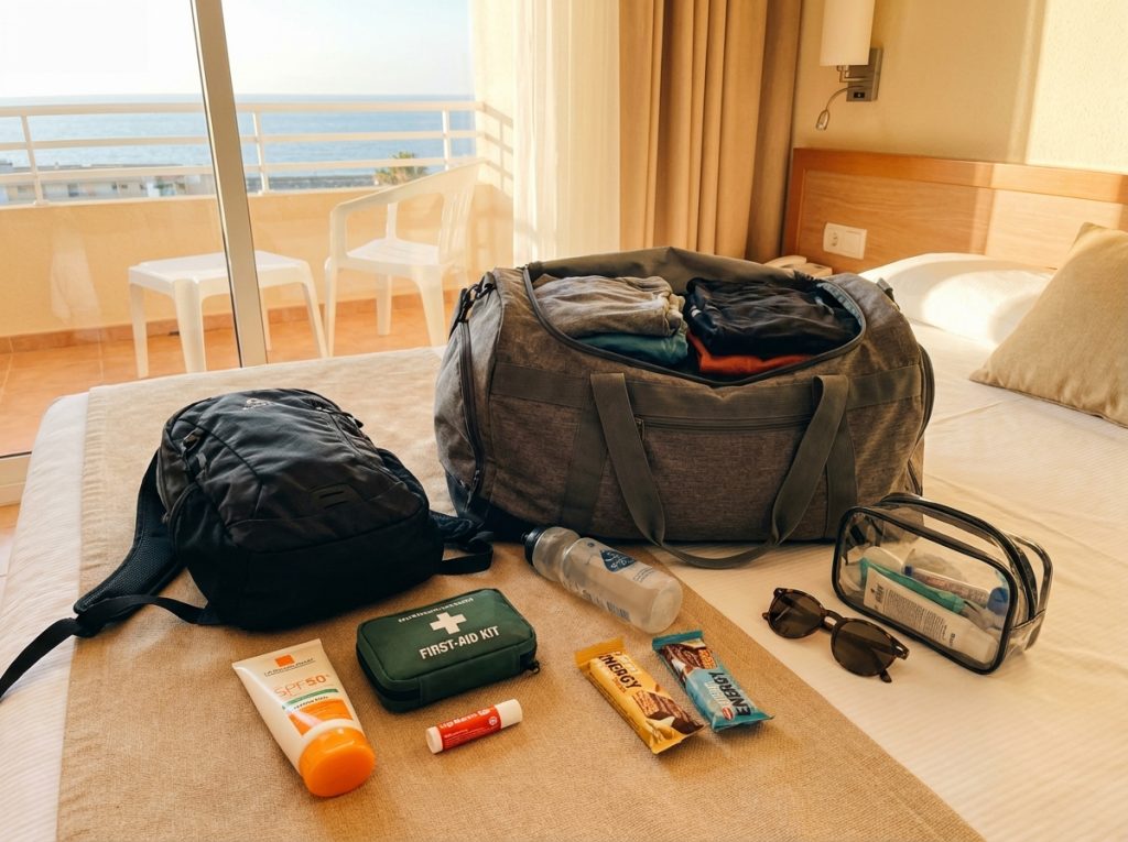
Self-Guided Cycling Tours in Costa Blanca: The Complete Packing List Guide
Key Takeaways
| Essential Category |
Must-Have Items |
Why It Matters |
| Cycling Clothing |
2 pairs bib shorts, 3 jerseys, cycling gloves |
Comfort on 100km+ rides with proper chamois padding |
| Weather Layers |
Light rain jacket, arm/leg warmers, fleece |
Costa Blanca’s variable temperatures (10-30°C) |
| Repair Tools |
Multitool, 3 spare tubes, mini pump |
Sparse bike shops in mountain areas |
| Navigation |
Smartphone + mount, offline GPS maps |
Self-guided means no support vehicle |
| Sun Protection |
SPF50+ sunscreen, lip balm, UV jerseys |
Intense Mediterranean sun at altitude |
| Luggage Strategy |
One 40L duffel + carry-on |
Weight limits and daily transfers |
Getting ready for a self-guided cycling adventure in Costa Blanca? You’re in for an amazing ride through one of Spain’s most diverse cycling regions. But here’s the thing – packing for Costa Blanca isn’t like preparing for your local weekend rides. One minute you’re sweating on coastal flats, the next you’re climbing steep mountain passes where the temperature drops 15 degrees and the wind picks up.
I learned this the hard way on my first trip when I packed like I was going on a supported tour. Big mistake! Self-guided tours mean you’re on your own out there, especially in those remote mountain areas where bike shops are few and far between.
Understanding Costa Blanca’s Unique Cycling Demands
What makes Costa Blanca special for cyclists? It’s the incredible variety. You’ll ride from sea level beaches to mountain climbs over 1,500 meters, often in the same day. The weather can shift dramatically too – coastal areas might hit 30°C while mountain passes sit at 15°C with strong winds.
Tour operators typically provide basic gear like helmets, water bottles, and simple repair kits. They’ll also handle your luggage transfers between hotels. But don’t assume they’ve got everything covered. Most provide a multitool, one spare tube, and a basic pump – that’s it for repairs. When you’re 50km from the nearest bike shop on a mountain descent, you’ll want more than that.
The terrain demands respect too. Routes like Benidorm To Guadalest Scenic Ride include serious climbing with gradients that’ll test your gearing and your legs. Pack smart, because every gram counts when you’re grinding up those climbs.
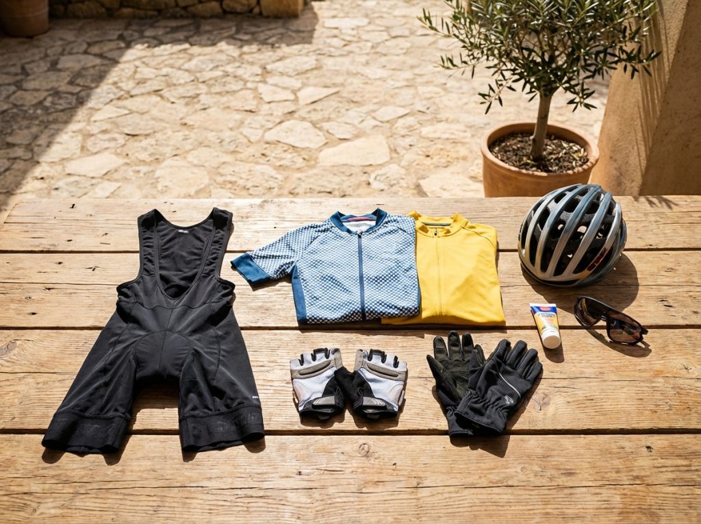
Essential Cycling Gear That Can’t Be Compromised
Let’s talk about the non-negotiables. First up – bib shorts with proper chamois padding. I can’t stress this enough. Regular athletic shorts might feel fine for your 20km weekend rides, but try wearing them on a 100km day with climbs like Cumbre del Sol and you’ll understand why every serious cyclist swears by bibs.
Pack two pairs minimum. Why two? Because you’ll want a clean pair while the other dries, and if one gets damaged or you have a chamois issue, you’re not stuck with regular shorts for the rest of your tour.
Your jersey selection matters just as much. Bring 2-3 breathable, quick-dry jerseys – preferably with good UV protection. Costa Blanca’s sun is intense, especially at altitude where you might not realize you’re getting burned until it’s too late. One long-sleeve jersey is worth its weight for sun protection on those exposed mountain climbs.
Cycling gloves are often overlooked but absolutely essential. Pack one fingerless pair for warm weather and one full-finger wind-resistant pair. Your hands take a beating on long rides, and blisters from poor grip can ruin your tour faster than a mechanical issue.
Don’t forget cycling shoes if you prefer clipless pedals. Most rental bikes come with basic platform pedals, but if you’re bringing your own pedals, make sure you have the right shoes to match.
Weather-Smart Layering for Variable Conditions
Costa Blanca’s weather variability is both a blessing and a challenge. Coastal temperatures range from 20-30°C, but head into the mountains and you might encounter 10-20°C with significant wind chill on descents.
Your rain jacket needs to be lightweight and packable – you don’t want bulk when it’s stuffed in a jersey pocket. Look for something with hi-vis elements too, because visibility matters when you’re navigating mountain roads with limited sight lines.
Arm and leg warmers are your secret weapons. They pack tiny but transform your comfort level when conditions change. I always bring two pairs because they’re so useful – you might want leg warmers for a cold morning start but arm warmers for a windy afternoon descent.
A lightweight fleece or vest works as your base layer for temperature regulation. Skip heavy jackets – they take up too much space and don’t offer the flexibility you need when conditions change rapidly.
For your extremities, pack waterproof overshoes (at least toe covers), a buff or neck warmer, and one pair of winter gloves. These small items make the difference between a comfortable ride and a miserable experience when weather turns.
Mechanical Preparedness for Remote Areas
Here’s where self-guided tours differ dramatically from supported ones. When you’re exploring routes like Mountain Biking Trails In Costa Blanca Finestrat Forest Trail, you might be hours from the nearest bike shop.
Your multitool should include all standard Allen keys plus a chain tool. Don’t rely on the basic tool provided by tour operators – it might not have everything you need for your specific bike setup.
Spare inner tubes are critical – pack 2-3 plus a patch kit. Costa Blanca’s roads can be rough, and mountain descents are hard on tires. Tire levers are essential too, because getting a tight tire off the rim with your hands alone is nearly impossible.
A quality mini pump or CO2 cartridges (bring 2-3) will save your ride. Test your pump with your valve type before you travel – there’s nothing worse than discovering incompatibility on a remote mountain road.
Chain lube and a quick-link are often overlooked but can save your tour if you have chain issues. Spare brake pads are worth considering too, especially for mountain routes where you’ll be doing a lot of braking on long descents.

Navigation and Safety for Independent Touring
Self-guided means exactly that – you’re responsible for finding your way. Your smartphone with a quality mount is essential, but don’t rely on it exclusively. Download offline GPS tracks before you ride, because cell signal can be spotty in mountain areas.
Apps like Komoot work well for Costa Blanca’s marked and unmarked routes. Having backup paper maps isn’t old-fashioned – it’s smart planning for when technology fails.
Safety equipment should include hi-vis elements, especially if you might be riding into dusk. Basic lights can be lifesavers if you’re caught out longer than expected.
Most tour operators provide bike locks, but verify this beforehand. You’ll want security when stopping for meals or sightseeing breaks.
For routes that require extra planning, check out guides like Self Guided Cycling Tours In Costa Blanca How To Plan A Self Guided Tour for detailed preparation tips.
Personal Care Essentials for Mediterranean Cycling
Costa Blanca’s intense Mediterranean sun demands serious protection. SPF50+ sunscreen isn’t overkill – it’s essential. Reapply every hour, especially on exposed climbs where the sun reflects off light-colored rocks.
Lip balm with UV protection is often forgotten but critical. Your lips are constantly exposed and burn easily at altitude.
Pack a compact first aid kit with basics: bandages, antiseptic wipes, pain relievers, and definitely chamois cream. Saddle sores can develop quickly on multi-day tours, and prevention is much easier than treatment.
Keep your personal medications in your carry-on bag, not your transferred luggage. If there’s a delay or mix-up with transfers, you’ll still have access to essential medications.
Consider the altitude factor too. Even moderate climbs in Costa Blanca can affect some riders, and the intense sun at elevation increases burn risk significantly.
Smart Off-Bike Clothing Strategy
Your evening wardrobe needs to be minimalist but functional. Stick to 2-3 days’ worth of casual clothing and plan to wash frequently. Most cycling-friendly accommodations have laundry facilities or quick-wash services.
Pack 2-3 comfortable t-shirts or polos – one short-sleeve, one long-sleeve for variety. One or two pairs of casual trousers or shorts will cover dinner and sightseeing needs.
Your sweater should be lightweight but warm enough for cooler mountain evenings. Coastal areas stay warm, but inland towns can get chilly after sunset.
Underwear and socks should be quick-dry materials – pack about 5 pairs of each. This gives you flexibility for washing schedules and ensures you always have dry options.
Footwear should be minimal: flip-flops for easy slip-on comfort and one pair of walking shoes for sightseeing. Don’t pack multiple shoe options – they take up too much space and weight.
A bathing suit is worth including, especially for coastal routes where you’ll have opportunities for Mediterranean swims between ride days.
Hydration and Nutrition Strategy
Dehydration hits fast in Costa Blanca’s heat and climbs. Most tour operators provide basic water bottles, but consider bringing insulated bottles for better temperature control.
Electrolyte tabs or powder are essential – you’ll lose significant sodium through sweat, especially on climbs. Pack enough for 4-6 servings per day.
Energy gels and bars should be brands you’ve tested at home. Costa Blanca’s climbing demands quick energy, and you don’t want to discover digestive issues mid-tour. The elevation gains on routes like the Inland Scenic Cycling Routes Jalon Valley Scenic Loop require proper fueling strategy.
Plan for about 1 liter of fluid per hour in Costa Blanca’s heat. That might sound like a lot, but it’s realistic for summer riding with significant climbing.
Luggage Optimization for Transfer Tours
Tour operators handle daily luggage transfers, but they have weight and size restrictions. Most limit bags to 20kg and prefer duffel bags over hard suitcases for easier handling.
Your main bag should be 40L maximum – enough for 5-7 days of cycling gear without excess bulk. Duffel bags work better than rigid suitcases because they’re easier for transfer staff to handle and fit better in support vehicles.
The daily carry bag is usually provided – typically a handlebar bag or small frame bag. This should hold your phone, snacks, basic tools, and emergency cash. Keep the weight under 2kg to avoid affecting bike handling.
Pack a small carry-on with essential items: one change of clothes, medications, important documents, and basic toiletries. This protects you if there are transfer delays or luggage mix-ups.
Label everything clearly. Tour operators usually provide luggage tags, but having backup identification helps prevent mix-ups between groups.
Travel Documents and Emergency Planning
Keep your passport or ID in a waterproof document pouch, along with copies of important papers. Travel insurance is mandatory, but make sure it specifically covers cycling activities.
Your insurance should include coverage for bike rental damage, medical evacuation, and trip interruption. Some policies exclude “adventure sports” which might include cycling.
Emergency contacts should include your home contact, tour operator, local emergency services (112 in Spain), and your insurance company’s 24-hour claim line.
Power banks and charging cables are essential for keeping your navigation devices running on long ride days. Pack universal adapters for European outlets.
Keep digital copies of important documents on your phone, backed up to cloud storage. If physical documents are lost or damaged, you’ll still have access to key information.
Store emergency cash in multiple locations – some in your daily bag, some in your main luggage, and some on your person. Small denominations are most useful for roadside stops or emergencies.
Frequently Asked Questions
What’s the most important item to pack for Costa Blanca cycling tours? Proper bib shorts with quality chamois padding are absolutely essential. Without them, long rides with significant climbing become uncomfortable or even impossible to complete.
How much clothing should I pack for a 7-day self-guided tour? Pack for 2-3 days and plan to wash regularly. This means 2 pairs of bib shorts, 3 cycling jerseys, and 2-3 days of casual evening wear. The key is quick-dry materials and frequent washing.
Do I need to bring my own bike repair tools? Yes, beyond the basics provided by tour operators. Pack additional spare tubes, a quality multitool, chain lube, and CO2 cartridges. Bike shops are scarce in mountain areas.
What’s the biggest packing mistake cyclists make for Costa Blanca? Overpacking and not preparing for variable weather. The temperature difference between coast and mountains can be 15°C or more, and weather changes quickly in mountain areas.
Should I bring clipless pedals and shoes? Only if you’re committed to using them and have the right shoes. Most rental bikes come with platform pedals, and clipless systems add complexity for luggage transfers.
How important is sun protection in Costa Blanca? Critical. Pack SPF50+ sunscreen, UV-protective clothing, and lip balm. The Mediterranean sun is intense, especially at altitude, and you’ll be exposed for hours during long rides.
by Ralf Tenbrink | 23, Mar 2026 | Bike Tours, Self-Guided Cycling Tours in Costa Blanca
Best Apps for Route Navigation
Key Takeaways
| Feature |
Top Recommendation |
Why It Matters |
| Best Overall App |
Ride with GPS |
Superior customization and browser-based planning |
| Best Offline Navigation |
Komoot |
Reliable offline maps for Costa Blanca’s remote areas |
| Best Community Routes |
Bikemap |
Millions of user-contributed routes with local insights |
| Best Free Option |
Google Maps |
Excellent bike routing with real-time hazard alerts |
| Best for Beginners |
Cyclers |
Personalized routes based on skill level and bike type |
| Essential Feature |
Offline Downloads |
Critical for signal-poor areas in Valencian mountains |
| Local Route Highlight |
Blanca Bikes Café Trail |
Popular 25km route through Parcent valley |
| Navigation Priority |
Voice Guidance |
Hands-free directions during challenging climbs |
Costa Blanca offers some of Spain’s most spectacular cycling terrain, from coastal paths hugging the Mediterranean to challenging mountain routes through Sierra de Aitana. With over 300 sunny days per year and 500 kilometers of coastline, this region has become a magnet for cycling enthusiasts. But what makes or breaks a self-guided tour isn’t just the weather – it’s having the right navigation tools to explore safely and efficiently.
Why do apps matter so much here? The terrain varies dramatically within short distances. You might start on flat coastal roads near Alicante and find yourself climbing 1000-meter peaks within an hour. GPS signal can drop in the mountain ravines, making offline capabilities essential. Plus, local knowledge about bike-friendly cafes, repair shops, and scenic detours can transform a good ride into an unforgettable experience.
Top Navigation Apps Ranked for Costa Blanca Cycling
Let me break down the best apps based on real-world testing in Costa Blanca’s unique conditions. Each has strengths that shine in different situations.
Ride with GPS takes the crown for serious cyclists who want complete control over their routes. The browser-based route builder lets you plot courses with incredible precision – crucial when navigating the winding roads around Guadalest or planning loops that avoid heavy traffic on the N-332 coastal highway. I’ve used it to create custom routes that hit three mountain villages in a single 80-kilometer ride, something that would be nearly impossible with basic mapping apps.
The community aspect proves invaluable too. Other cyclists share detailed routes with elevation profiles, surface conditions, and local tips. One popular route I discovered through their platform takes you from Benidorm to Guadalest with stops at traditional Spanish cafes that most tourists never find.
Komoot excels when you venture off the beaten path. Its topographic maps and offline capabilities saved me during a gravel ride through the Jalon Valley when cell service disappeared for 20 kilometers. The app’s voice navigation works brilliantly with bone conduction headphones, letting you hear traffic while getting turn-by-turn directions.
What sets Komoot apart is its point-of-interest database. It actually includes the famous Blanca Bikes Café route in Parcent – a 25-kilometer gem that winds through almond groves and offers stunning valley views. The app also suggests coffee stops, viewpoints, and even bike shops along your route.
Bikemap brings the power of community knowledge to your handlebars. With millions of user-contributed routes, you’ll find everything from family-friendly coastal paths to challenging mountain ascents. The surface information feature tells you whether you’re heading onto gravel, helping you choose the right bike and tires.
The premium version includes turn-by-turn navigation and offline maps, but even the free version provides route inspiration. I discovered several mountain biking trails in Costa Blanca through Bikemap that I never would have found otherwise.
Google Maps might seem basic, but don’t underestimate it for cycling in Costa Blanca. Its bike routing algorithm has improved dramatically, and the real-time hazard alerts can warn you about construction on busy roads like the CV-70 between Calpe and Altea. The elevation profiles help you prepare mentally for climbs, and the local business information ensures you’ll find that crucial café stop.
Cyclers deserves mention for its intelligent route personalization. Input your bike type, fitness level, and preferences, and it generates routes that match your capabilities. For beginners tackling Costa Blanca’s hills for the first time, this takes the guesswork out of planning.
Must-Ride Routes with App Recommendations
The Coastal Loop from Calpe to Denia showcases everything Costa Blanca offers cyclists. This 60-kilometer route combines flat coastal sections perfect for enjoying sea views with challenging climbs up to scenic viewpoints.
Starting from Calpe’s iconic Peñón de Ifach, you’ll pedal through traditional fishing villages and modern resort towns. The route includes several challenging sections where having reliable navigation becomes crucial. The climb out of Moraira toward Teulada gains 300 meters in just 5 kilometers – definitely not the place to take a wrong turn and add unnecessary climbing.
For this route, I recommend using Ride with GPS for the initial planning, then downloading the GPX file to both Komoot and Google Maps as backups. The coastal sections have excellent cell coverage, but the inland portions around Teulada can be spotty.
The Alicante to Calpe Long Distance Ride represents the ultimate Costa Blanca challenge. At 120 kilometers with over 1,800 meters of elevation gain, this epic journey takes you through five distinct climate zones and showcases the region’s incredible diversity.
The route begins in Alicante’s urban environment, crosses the salt flats near Santa Pola, climbs through the wine regions around Pinoso, and finishes with the dramatic coastal descent into Calpe. Navigation becomes critical through the middle sections where rural roads can confuse even experienced cyclists.
For routes of this magnitude, offline capability isn’t optional – it’s essential. I learned this the hard way during a ride through the mountains above Alcoy when my phone lost signal for 40 minutes. Having Komoot’s offline maps downloaded saved what could have been a very long and frustrating detour.
The Jalon Valley Scenic Loop offers something completely different. This 45-kilometer circuit takes you through traditional Spanish countryside, past almond groves, orange orchards, and whitewashed villages that seem frozen in time.
What makes this route special isn’t just the scenery – it’s the complete change of pace from coastal cycling. The roads are quieter, the gradients more forgiving, and the cultural experience more authentic. You’ll stop in villages where English isn’t spoken, making good navigation even more important.
I’ve spent countless hours testing these apps on Costa Blanca’s varied terrain, and the differences become apparent quickly. During a challenging ride from Villajoyosa to Relleu, Ride with GPS provided the most accurate elevation data, helping me pace the climb properly. The route included several unmarked turns that only appeared correctly in the GPS track – relying on road signs alone would have led to confusion.
Komoot’s strength showed during a gravel adventure in the Sierra de Aitana mountains. When the designated route became impassable due to recent rains, the app quickly recalculated an alternative that kept me on suitable surfaces. The voice navigation worked flawlessly even when wearing a helmet, and the offline maps meant no worrying about data charges while roaming.
One memorable test involved using different apps simultaneously during the same 80-kilometer ride from Benidorm to Guadalest and back. Google Maps excelled at finding bike-friendly routes through urban areas and provided excellent traffic updates. However, it struggled with the mountain sections where Komoot’s topographic data proved superior.
Bikemap surprised me with its community features. Other cyclists had marked road construction, dangerous intersections, and even the best viewpoints for photos. This crowdsourced information transformed a routine training ride into a mini adventure with discoveries I never would have made alone.
The battery usage comparison proved interesting too. Ride with GPS, running constantly with the screen on, consumed about 15% battery per hour. Komoot’s more efficient offline mode used roughly 8% per hour, while Google Maps fell somewhere between at 12% hourly consumption.
Essential Features for Costa Blanca Cycling
Offline capability tops every cyclist’s must-have list here. The mountainous terrain creates numerous dead zones where cell towers can’t reach. I’ve experienced signal drops lasting 30-45 minutes in areas like the Coll de Rates pass and the remote sections of the Villajoyosa to Relleu route.
Without offline maps, you’re essentially cycling blind through unfamiliar terrain. This isn’t just inconvenient – it can be dangerous when you’re on narrow mountain roads with limited visibility and no shoulder space.
Voice navigation becomes critical when tackling Costa Blanca’s challenging climbs. When you’re grinding up a 12% gradient with your heart rate in the red zone, the last thing you want is to stop and check your phone for directions. Quality voice guidance lets you focus on maintaining rhythm and staying safe.
The integration quality varies significantly between apps. Komoot’s voice prompts are clear and timely, giving you plenty of warning before turns. Google Maps sometimes provides directions too late, especially on fast descents where reaction time matters.
Elevation profiles and gradient warnings help tremendously with pacing and gear selection. Costa Blanca’s topology can be deceptive – what looks like a gentle rise on the map might be a leg-burning 15% ramp that requires completely different tactics.
Ride with GPS provides the most detailed elevation data, including grade percentages and maximum gradients for upcoming sections. This information proved invaluable during my first attempt at the notorious Port de Tudons climb near Callosa d’En Sarria.
Pro Tips for Self-Guided Costa Blanca Tours
Download multiple route options before heading out. Weather conditions, road closures, or simply feeling stronger or weaker than expected might require plan changes. Having alternatives already loaded prevents disappointing route modifications mid-ride.
I always prepare a shorter bailout option for longer routes. The Long Distance Ride Alicante to Calpe includes several towns with good train connections back to your starting point if needed.
Battery management becomes crucial on longer rides. Invest in a good power bank and consider using your phone’s power saving mode when navigating. Some cyclists prefer dedicated GPS devices, but smartphone apps offer much better route flexibility and community features.
Consider bringing backup navigation methods too. A basic cycling computer with breadcrumb navigation can get you home if your phone fails completely. It’s also worth writing down key turn directions and landmarks for critical route sections.
Weather integration shouldn’t be overlooked. Costa Blanca’s mountain weather can change rapidly, and what starts as a perfect sunny morning might turn into a challenging ride through fog or unexpected rain showers. Apps that integrate weather data help you make informed decisions about route timing and equipment choices.
The coastal winds here are particularly noteworthy. The famous “Levante” easterly wind can turn a pleasant coastal ride into a grueling battle, especially on exposed sections between Calpe and Altea. Planning your route direction based on wind forecasts makes a significant difference in ride enjoyment.
Safety Considerations and Emergency Features
Costa Blanca’s cycling popularity unfortunately doesn’t always translate to cycling awareness among drivers. The apps’ safety features become genuinely important, especially when navigating busy sections like the approach to Benidorm or the industrial areas around Elche.
Google Maps excels at highlighting bike lanes and safer route alternatives. It steered me away from a dangerous section of the N-332 near La Vila Joiosa during heavy traffic, routing me through quieter parallel roads that added only 2 kilometers but probably saved my life.
Emergency contact features deserve serious consideration. Several apps now include crash detection and can automatically alert emergency contacts if you stop moving suddenly. While these features can produce false alarms, they provide peace of mind when cycling solo in remote areas.
Komoot’s emergency contact sharing lets trusted friends track your location during longer rides. I use this feature religiously when tackling challenging mountain routes where help might be hours away if something goes wrong.
Route sharing capabilities also enhance safety. Sharing your planned route with accommodation hosts, local bike shops, or cycling buddies means someone knows where to look if you don’t return as expected. Most apps make this process simple with one-click sharing options.
For cyclists staying in one of the cycling friendly accommodations in Calpe, showing your route to hotel staff can provide valuable local insights about current road conditions or alternative routes.
2026 App Updates and Future Features
The cycling app landscape evolves rapidly, with 2026 bringing several exciting developments that benefit Costa Blanca cyclists specifically. Artificial intelligence integration is becoming more sophisticated, with apps learning your preferences and fitness patterns to suggest increasingly personalized routes.
Komoot’s latest AI features analyze your riding history and automatically suggest routes matching your current fitness level and preferred scenery types. After tracking several months of Costa Blanca rides, it now recommends routes with the perfect balance of coastal views and manageable climbing.
Enhanced weather integration represents another significant improvement. Modern apps don’t just show current conditions – they predict how weather changes will affect your specific route and timing. This proves particularly valuable in Costa Blanca’s microclimates where coastal conditions can differ dramatically from mountain weather just 20 kilometers inland.
Real-time surface condition reporting is expanding too. Cyclists can now report road conditions, construction, or hazards directly through apps, creating a constantly updated database of route intelligence. This crowdsourced information proves invaluable for avoiding problems before they ruin your ride.
Electric bike integration continues improving as well. Apps now include charging station locations, battery range calculations based on terrain, and even suggestions for e-bike friendly routes that maximize range while still providing engaging cycling experiences.
The integration with local services is expanding beyond basic points of interest. Some apps now connect directly with bike shops for maintenance scheduling, restaurant reservations, or even emergency mechanical support – particularly useful when you’re far from your base and need professional help.
Frequently Asked Questions
Which app works best without internet connection in Costa Blanca mountains? Komoot provides the most reliable offline navigation for mountain areas. Download maps for the entire Costa Blanca region before heading out, as signal drops are common in valleys and remote mountain sections. The offline maps include detailed topographic information crucial for mountain navigation.
Can I use these apps with a Spanish phone plan or do I need special data packages? Most Spanish phone plans include sufficient data for GPS navigation, but be aware that constant screen-on navigation consumes significant battery and data. Download offline maps when connected to WiFi to minimize data usage during rides.
How accurate are elevation profiles for Costa Blanca’s steep climbs? Ride with GPS provides the most accurate elevation data, often within 5-10 meters of actual gradients. This accuracy proves crucial for pacing efforts on challenging climbs like the Port de Tudons or the ascent to Guadalest castle.
Do these apps work with cycling computers and heart rate monitors? Yes, most apps integrate with popular cycling computers and fitness devices. Ride with GPS and Komoot both sync with Garmin devices, while smartphone apps typically connect via Bluetooth to heart rate monitors and power meters.
What’s the best app for finding bike-friendly cafes and rest stops? Komoot excels at finding cycling-specific points of interest, including the famous bike cafes scattered throughout Costa Blanca. The app includes user reviews and photos of stops, helping you plan rest breaks at cyclist-friendly locations.
How do I handle navigation if my phone battery dies during a long ride? Always carry a power bank on rides longer than 50 kilometers. Additionally, write down key navigation points and carry a basic paper map as backup. Some cyclists use dedicated GPS devices as secondary navigation systems.
Are there specific apps for mountain biking versus road cycling routes? While most apps handle both disciplines, Komoot provides superior trail information for mountain biking, including surface conditions and technical difficulty ratings. For road cycling, Ride with GPS offers better traffic-aware routing and performance analysis features.
How far in advance should I plan routes for Costa Blanca cycling tours? Plan major routes at least 24-48 hours in advance to allow time for offline map downloads and route alternatives research. Check local cycling forums and recent user reviews for current road conditions, especially during construction season from October through March.
by Ralf Tenbrink | 18, Mar 2026 | Bike Tours, Mountain Biking Trails in Costa Blanca
Javea Mountain Biking Route
Key Takeaways
| Aspect |
Details |
| Available Routes |
Montgó (27km), Capsades/Tossal Gros (18.7km) |
| Difficulty Level |
Moderate to high with 440m+ elevation gain |
| Starting Point |
Arenal Beach (Montgó route) |
| Best For |
Experienced MTB riders seeking forest trails |
| Route Type |
Forest paths, vineyard sections, river routes |
Important Note: The available research doesn’t provide detailed information about a specific “Javea Forest MTB Loop” as a defined route. The content below synthesises available information about MTB trails in the Javea area, but readers should verify specific route details, GPS coordinates, and current trail conditions through local sources or recent user reviews before riding.
Discovering Javea’s Mountain Biking Terrain
Javea offers several established mountain biking routes that traverse the area’s diverse landscape. The most documented routes include the Montgó circuit and the Capsades trail system, both providing different challenges for off-road enthusiasts.
Why do these routes attract serious mountain bikers? The terrain combines forest paths, vineyard sections, and challenging elevation changes that test both technical skills and endurance. The Montgó route covers approximately 27 kilometres, whilst the Capsades/Tossal Gros circuit spans 18.7 kilometres.
Local riders often combine sections from different routes to create longer adventures. This flexibility allows you to adjust distance and difficulty based on your fitness level and available time. The forest sections provide natural shade during summer months, making these routes more comfortable than exposed coastal paths.
Trail conditions vary significantly between seasons. Spring offers the best combination of mild weather and firm trail surfaces. Summer brings heat that makes early morning starts essential. Autumn provides excellent visibility but watch for wet leaves on technical sections.
The elevation profiles show moderate to high difficulty ratings, with climbs reaching 440 metres of gain. This isn’t beginner territory – you need solid bike handling skills and reasonable fitness to complete these routes safely.
Most routes connect to the broader mountain biking trails network in Costa Blanca, allowing for extended touring opportunities.
Montgó Route: Technical Forest Challenge
The Montgó route begins at Arenal Beach and immediately challenges riders with a steady climb towards the 753-metre peak. This isn’t a route for casual weekend riders – the initial ascent demands strong legs and proper gearing.
What makes this route technically demanding? The forest sections include loose rock surfaces, narrow singletrack passages, and steep gradient changes that require precise bike control. Riders report sections where dismounting becomes necessary, particularly on the steepest climbs approaching the Montgó summit area.
Navigation requires attention throughout the route. Forest paths can become unclear during poor weather conditions. GPS devices or smartphone apps with offline maps are essential – mobile signal coverage becomes patchy in the deeper forest sections.
The descent sections offer thrilling riding but demand respect. Loose gravel and sudden turns require controlled speed and proper braking technique. Full-face helmets aren’t overkill for this terrain – several local riders recommend them for the technical descents.
Water carrying capacity becomes crucial on this 27-kilometre route. The climbing sections generate significant sweat loss, and refill opportunities are limited once you leave the beach area. Plan for at least 1.5 litres per rider on warm days.
Forest wildlife occasionally crosses the trails. Wild boar tracks are common, though actual encounters remain rare during daylight hours. Make noise on blind corners and avoid riding alone in early morning or late afternoon periods.
Proper chain maintenance becomes critical on these dusty, demanding trails.
Capsades Trail Network: Shorter But Intense
The 18.7-kilometre Capsades/Tossal Gros route provides a more concentrated challenge than the longer Montgó circuit. This network focuses on technical forest riding rather than distance achievements.
Trail character changes dramatically between sections. The initial forest approach offers flowing singletrack that builds confidence. Then the terrain shifts to rocky, technical climbing that tests both bike setup and rider skill.
Tossal Gros sections include some of the most challenging terrain in the Javea area. Steep, loose climbs require careful line choice and momentum management. Many riders find the 34-tooth climbing gear still isn’t low enough for the steepest pitches.
The vineyard crossings provide welcome relief from intense forest riding. These sections flow smoothly and offer opportunities to recover before the next technical challenge. However, respect private property boundaries and stick to marked paths.
Rocky descents demand full attention. The combination of loose stones, tight corners, and gradient changes creates challenging conditions. Modern mountain bikes with dropper posts and wide tyres perform best on this terrain.
Local knowledge suggests early morning rides encounter the best trail conditions. Afternoon heat makes the rocky sections particularly demanding, and dust levels increase significantly with multiple riders.
Weather affects this route more than coastal alternatives. Rain makes rocky sections treacherous, and mud accumulates in forest areas for days after storms. Check recent conditions before attempting challenging sections.
Professional bike maintenance becomes essential after repeated rides on this abrasive terrain.
Essential Route Planning and Navigation
Successful mountain biking in the Javea area requires thorough preparation and proper equipment. GPS navigation tools are mandatory – mobile phone coverage becomes unreliable in forest sections, making offline maps essential.
Route verification through multiple sources is crucial. The available documentation lacks detailed turn-by-turn directions, specific landmarks, or recent condition reports. Local bike shops provide the most current information about trail conditions and access restrictions.
Water and food planning requires careful consideration. The combination of heat, elevation gain, and technical terrain creates high energy demands. Plan for 250-300 calories per hour of riding, plus extra reserves for navigation delays or mechanical issues.
Emergency contact procedures need establishment before starting longer routes. Mobile signal coverage varies significantly across the trail networks. Share your planned route and expected return time with reliable contacts.
Trail etiquette becomes important as these routes cross private land and sensitive natural areas. Stick to established paths, avoid riding during wet conditions that damage trails, and respect any seasonal access restrictions.
Mechanical preparation can prevent serious problems. The rocky, technical terrain causes higher-than-normal wear on brake pads, tyres, and drivetrain components. Pre-ride safety checks should include brake function, tyre pressure, and chain condition.
Most experienced riders recommend morning starts to avoid afternoon heat and potential thunderstorms. Summer conditions in particular make afternoon riding dangerous due to dehydration risk and reduced visibility from dust.
Consider linking with other Costa Blanca mountain biking adventures to extend your riding experience.
Terrain Analysis and Difficulty Assessment
The elevation profiles for Javea mountain biking routes show significant vertical challenges that separate these trails from casual riding options. With 440+ metres of climbing over relatively short distances, the power-to-weight ratio becomes a limiting factor for many riders.
Technical terrain analysis reveals specific skill requirements. The forest sections combine loose rock surfaces with narrow trail widths that demand precise steering control. Riders report that standard cross-country mountain bike skills aren’t sufficient – trail bike or enduro experience provides better preparation.
Gradient analysis shows sustained climbs rather than short, sharp ascents. This creates different physiological demands compared to coastal routes with brief hills. Pacing becomes critical to avoid early exhaustion that compromises bike handling on technical descents.
Surface conditions vary dramatically within single routes. Compact earth sections flow smoothly, but rocky areas require constant line choice decisions. Wet conditions transform moderately challenging sections into genuinely dangerous terrain.
Seasonal difficulty variations affect route planning. Summer heat adds significant cardiovascular stress to already demanding climbs. Spring conditions offer optimal trail surfaces but variable weather. Autumn provides stable temperatures but shorter daylight hours limit riding time.
The combination of elevation gain and technical terrain creates situations where walking becomes necessary. Plan routes with this possibility in mind – some sections simply exceed rideable limits for most mountain bikers.
Bike setup requirements differ from typical cross-country specifications. Wider tyres, lower gearing, and dropper posts improve safety and enjoyment on this challenging terrain.
Trailforks data confirms the technical nature of these routes through user difficulty ratings.
Local Trail Conditions and Seasonal Considerations
Trail maintenance levels vary across the Javea mountain biking network. Some sections receive regular attention from local cycling groups, whilst others rely on natural weather patterns and occasional hiker traffic to maintain rideable surfaces.
Wet weather creates lasting impact on trail conditions. The combination of clay soil and rocky terrain means that autumn and winter rain affects riding conditions well into spring months. Muddy sections become deeply rutted and potentially damaging to trail surfaces.
Summer drought conditions create different challenges. Dust accumulation reduces visibility on descents and creates slippery conditions on steep sections. The combination of heat and dust makes afternoon riding particularly uncomfortable and potentially dangerous.
Spring offers the most consistent trail conditions. Temperatures remain moderate, trail surfaces firm up from winter moisture, and vegetation growth hasn’t yet encroached on narrow sections. However, spring weather remains variable and sudden storms can catch riders unprepared.
Local wildlife activity influences safe riding times. Wild boar prefer dawn and dusk periods for foraging, making these times less suitable for solo riding in forest areas. Daylight hours between 9 AM and 5 PM generally offer the safest conditions.
Seasonal access restrictions may apply to specific trail sections during hunting periods or fire risk seasons. Local authorities can implement temporary closures with minimal advance notice during high fire danger periods.
Trail marking consistency varies between route sections. Some areas feature clear directional signs and distance markers, whilst others rely on faded paint marks or GPS navigation for route finding.
Consider exploring family-friendly alternatives if conditions aren’t suitable for technical riding.
Equipment Specifications and Safety Requirements
Modern mountain bike specifications become critical for safe completion of Javea’s challenging trail network. Full-suspension bikes with 120-140mm travel provide optimal performance on the rocky, technical terrain typical of these routes.
Tyre selection significantly affects both safety and enjoyment. Wide tyres in the 2.4-2.6 inch range offer improved grip and puncture resistance on sharp limestone rocks. Tubeless setups reduce puncture anxiety and allow lower pressures for better traction.
Dropper post functionality transforms the riding experience on these routes. The combination of steep climbs followed by technical descents makes quick saddle height adjustment essential for maintaining control and comfort.
Brake specifications require careful consideration. The sustained descents and loose surfaces demand consistent stopping power that basic mechanical disc brakes struggle to provide. Four-piston hydraulic systems offer the power and heat dissipation needed for safe descending.
Protective equipment recommendations exceed standard cross-country requirements. Full-face helmets provide worthwhile protection on rocky descents where crashes can involve facial impact with stones. Knee and elbow protection helps prevent injury during inevitable minor spills.
Navigation equipment must function reliably in areas with poor mobile coverage. GPS devices with preloaded maps or smartphones with offline mapping apps are essential. Power bank capacity should support all-day navigation use.
Emergency repair capabilities need expansion beyond basic puncture fixes. The rocky terrain causes higher failure rates for brake components, derailleur hangers, and chain links. Comprehensive tool kits and spare parts become necessary for remote trail riding.
Hydration planning requires consideration of heat, exertion, and limited refill opportunities. Hydration packs offering 2+ litre capacity work better than bottle systems for longer routes.
Professional waxing services help maintain drivetrain performance in dusty conditions.
Route Extensions and Connecting Adventures
The Javea trail network connects to broader Costa Blanca mountain biking opportunities, allowing experienced riders to create multi-day adventures or longer single-day challenges. Understanding these connections opens up significantly more riding possibilities.
Northern connections link to the Vall de Laguar systems. This extension adds approximately 15-20 kilometres but requires solid navigation skills and self-sufficiency for longer remote sections. The terrain becomes more technical with increased exposure to weather conditions.
Southern route options connect towards Calpe and the Sierra de Bernia networks. These extensions offer different geological formations and trail characteristics whilst maintaining challenging difficulty levels throughout.
The forest trail systems can connect to coastal routes for mixed-terrain adventures. However, the transition sections often involve road riding through built-up areas that reduce the wilderness experience.
Multi-day touring possibilities exist but require careful planning. Accommodation options that cater specifically to mountain bikers remain limited around Javea. Most hotels and rental properties don’t provide secure bike storage or workshop facilities.
Route combination strategies should consider cumulative fatigue effects. Adding distance to already challenging routes can push difficulty levels beyond safe limits for many riders. Conservative planning prevents problems in remote trail sections.
Weather windows become more critical for extended route combinations. Single-day routes offer flexibility to postpone rides during poor conditions, but multi-day plans require more accurate forecasting and backup options.
Transportation logistics for route combinations need advance planning. Car shuttles or return transportation become necessary for point-to-point route combinations that don’t form complete loops.
Explore self-guided tour planning resources for extended adventure preparation.
Frequently Asked Questions
Is the Javea Forest MTB Loop suitable for beginners? No, the available routes around Javea feature moderate to high difficulty levels with 440+ metres of elevation gain and technical rocky sections. Beginners should start with easier coastal routes and build skills before attempting forest trails.
What’s the best time of year for mountain biking in Javea? Spring (March-May) offers optimal conditions with moderate temperatures and firm trail surfaces. Summer requires early morning starts due to heat, whilst autumn and winter bring variable weather that can make trails dangerous when wet.
How long does it take to complete the main Javea mountain bike routes? The Montgó route (27km) typically requires 3-4 hours for experienced riders, whilst the Capsades circuit (18.7km) takes 2-3 hours. Times vary significantly based on fitness level, technical skill, and trail conditions.
What bike specifications are recommended for these trails? Full-suspension mountain bikes with 120-140mm travel work best. Wide tyres (2.4-2.6 inches), four-piston hydraulic brakes, and dropper posts significantly improve safety and performance on the technical, rocky terrain.
Are GPS devices necessary for navigation? Yes, GPS devices or smartphones with offline maps are essential. Mobile phone coverage becomes unreliable in forest sections, and trail marking inconsistency makes electronic navigation critical for safe route completion.
Can these routes be ridden year-round? Weather conditions significantly affect trail safety and rideability. Wet conditions make rocky sections dangerous, whilst summer heat creates dehydration risks. Spring and early autumn generally provide the most consistent riding conditions.
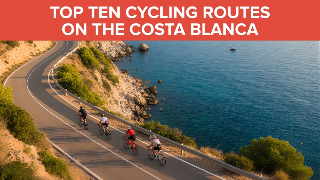
by Geroge Cornelius | 16, Mar 2026 | Bike Tours, Family-Friendly Cycling Routes, Mountain Biking Trails in Costa Blanca, Road Cycling Routes in Costa Blanca, Self-Guided Cycling Tours in Costa Blanca
Top 10 Cycling Routes in Costa Blanca: A Complete Guide
Key Takeaways
| Quick Facts |
Details |
| Best Season |
October – May (15-25°C, 300+ sunny days) |
| Top Route |
Coll de Rates – 6km switchback climb, pro favorite |
| Hardest Climb |
Xorret de Catí – 11.5% gradient, Vuelta a España stage |
| Beginner Pick |
Calpe to Moraira coastal cruise – gentle 65km |
| Pro Spotting |
Calpe (Team Ineos base), Rates climb |
| Safety Must |
Helmets mandatory, high-vis gear, wind apps |
Costa Blanca has become Europe’s cycling paradise, and I can see why after spending years exploring these routes. The microclimate here means you can ride almost any day of the year – something I learned the hard way when I first arrived in December expecting cold weather! These ten routes represent the absolute best the region offers, from gentle coastal cruises to brutal climbs that break professional pelotons.
Why Costa Blanca Dominates European Cycling Training
What makes Costa Blanca special? It’s not just the weather, though 300+ sunny days definitely help. The variety here is incredible – you can start with a flat coastal ride and end up grinding through mountain switchbacks all in the same day.
I’ve watched Chris Froome train on these very roads when Team Ineos set up their winter camp in Calpe. The mix of challenging climbs, smooth tarmac, and relatively light traffic creates perfect training conditions. Most importantly, the gradients here build progressively – you won’t find yourself hitting a 20% wall without warning.
The infrastructure keeps improving too. New bike lanes connect major towns, and most climbs have been resurfaced in recent years. Local authorities actually listen to cycling groups, which makes a huge difference compared to other European destinations.
Download GPX files from Strava or Epic Road Rides before heading out. I always check wind apps too – those coastal blasts can turn a pleasant ride into a proper battle. Spring brings wildflowers, fall offers perfect temperatures, and summer mornings beat the heat if you start early.
The Complete Costa Blanca Route Rankings
These rankings consider four key factors: popularity among pros and locals, difficulty balance, scenic value, and uniqueness. Each route has been tested multiple times in different conditions to give you the real story.
1. Coll de Rates: The Ultimate Costa Blanca Experience
This 6km climb from Parcent averaging 6% gradient represents everything great about Costa Blanca cycling. Endless hairpin turns sweep up through pine forests with perfect asphalt that makes you want to dance on the pedals.
The fastest pro times sit under 15 minutes, but don’t let that fool you into rushing. This climb rewards rhythm over power – find your groove and enjoy the most photographed switchbacks in Spain. I’ve ridden it dozens of times and still smile at those perfectly banked corners.
Why it tops our list: Vuelta a España legend status, unmatched popularity on Strava, and pure cycling joy without brutality. The 50km loop through valley vineyards and sea panoramas makes it perfect for any fitness level. Extend to Tarbena if you want more bite.
Practical details: Start from Parcent for the classic approach, or drive 20 minutes from Calpe. Low traffic midweek, fantastic coffee stops in Parcent village. Best ridden October through May when temperatures stay comfortable.
The view from the top stretches across the entire Mediterranean coastline. On clear days, you can spot Ibiza on the horizon – a sight that never gets old.
2. Xorret de Catí: Where Vuelta Dreams Die
This brutal 3.85km climb at 11.5% average gradient separates pretenders from contenders. Stage 8 of the 2023 Vuelta a España finished here, and watching the peloton shatter on those final ramps to 22% was pure carnage.
Starting from Boqueres, the climb begins innocuously before revealing its true nature. Single-lane roads mean no escape from the gradient – you either make it or you don’t. The 120km route via Alcoy adds beautiful meadows and plains views from the 1098m summit.
What makes it special: Genuine Vuelta history meets savage climbing. Pro training groups summit weekly, so don’t be surprised to find yourself chasing (or being dropped by) world-class riders. It’s exposed with no traffic, but that isolation adds to the challenge.
I recommend starting early and fueling properly in Boqueres – there’s nothing else until the top. Spring offers the best conditions, though winter rides can be magical if you dress appropriately. GPX files are available on Komoot for navigation.
The summit rewards suffer with panoramic views across Alcoy’s industrial plains. It’s not pretty, but it’s earned.
3. Port de Bernia: Freshly Paved Punishment
Freshly asphalted in 2019, this 5km beast averages 12% and splits into distinct ramps and recovery sections. The final 3.5km exceeds 15% gradient – a proper leg-shredder that features in the Volta a la Comunitat Valenciana.
The 40km loop from Calpe hits Sierra de Bernia vistas over Altea and the Mediterranean. What strikes me most is how quiet this climb stays despite its pro pedigree – most tourists stick to the coastal roads below.
Expert insight: The new asphalt changes everything. Before resurfacing, loose gravel made descending treacherous. Now it’s pure speed on smooth tarmac, though you still need caution on some corners.
Cafes in Bernia village provide perfect refueling stops, and the lack of through traffic makes it ideal for interval training. Avoid summer heat – this climb faces south and bakes in afternoon sun.
The technical nature rewards good bike handling. Short, steep ramps followed by brief recovery sections mean you need to manage effort carefully rather than just grinding away.
4. Puerto de Sa Creueta: The Perfect Recovery Ride
This gentle 7.5km climb at 3.4% average from Tarbena winds through almond groves to 800m+ Mediterranean views. It’s the perfect recovery after tackling Rates, offering stunning scenery without the leg-sapping gradients.
The 60km Jalón valley loop incorporating this climb has become legendary among local cycling groups. Rolling hills, zero traffic, and that final reward of sea views make it irresistible for weekend rides.
Hidden gem qualities: Absolutely no traffic due to its remote location. The road surface is decent, and there are perfect picnic spots at the summit. Year-round riding conditions, though fall during harvest season adds special atmosphere.
I often use this as a warm-up before tackling harder climbs, or as a gentle introduction for visiting friends. The gradient never punishes, and the scenery keeps getting better as you climb higher.
Strava segments are easy to find, and the descent is fast enough to be fun without being dangerous. Almond blossom season in February transforms the entire valley into something magical.
5. Cumbre del Sol: The Coastal Wall of Fire
This demanding coastal grind near Benidorm features ramps that rival Xorret de Catí. Part of epic 123km routes with 1671m of climbing, it combines sea-hugging descents with brutal uphill sections through clifftop roads.
The Mediterranean backdrop makes every pedal stroke scenic, but don’t let the beauty distract you from those 8-10% ramps. This is expert-level riding that demands respect and preparation.
Strategic considerations: Lower sections get busy with tourist traffic, making weekends risky for serious training. However, cafes are plentiful for refueling, and winter riding offers calm seas and clear views.
The cliff-edge drama is genuinely unique in Costa Blanca. Most climbs head inland to mountains, but this one stays coastal while still providing serious elevation gain.
Sea breezes can help or hinder depending on direction. Check wind forecasts and plan your route timing accordingly – afternoon headwinds can turn challenging into impossible.
6. Calpe to Moraira and Jávea: Mediterranean Perfection
This 65km moderate roller from Calpe via Moraira to Jávea hugs the Mediterranean with the iconic Peñón de Ifach rock formation, beaches, and gentle hills mixing flats with manageable climbs.
Perfect for intermediate cyclists or as an active recovery ride, it showcases why Costa Blanca attracts cyclists of every level. Extend to Denia for a 50km historic add-on that includes some of the region’s best coastal scenery.
Accessibility factors: Cycle paths avoid the worst N-332 traffic, and beach cafes provide regular refueling opportunities. This route works any time of year, though sunrise rides offer the best light and minimal traffic.
I recommend this to every first-time visitor because it captures Costa Blanca’s essence – stunning coastline, manageable challenges, and that perfect Mediterranean cycling atmosphere.
The Peñón de Ifach creates a natural landmark that’s visible for most of the ride. Those views never get old, and there are dozens of photo opportunities along the way.
7. Vall de Gallinera: The Hidden Valley Secret
This poppy-lined 80km loop through the untouched Gallinera Valley features progressive climbs of 5-7% through olive terraces and past waterfalls. Rare traffic and genuine wildlife sightings including eagles make it feel like stepping back in time.
The valley remains largely unknown to cycling tourists, which preserves its authentic character. Stone villages, traditional farming methods, and roads that wind naturally with the landscape create a completely different Costa Blanca experience.
Off-the-beaten-path rewards: Pot-holed sections require cautious descending, but village tapas stops offer authentic local cuisine. Spring wildflower blooms peak in March and April. GPX files via Outdooractive help with navigation.
This represents ultimate uniqueness in our rankings – a genuine hidden gem that rewards adventurous cyclists. The climbing is steady rather than brutal, making it perfect for building endurance.
Eagle sightings are common, and the valley’s microclimate means comfortable riding even when coastal areas get too hot or windy.
8. Puerto de Tudons: Gateway to Aitana Epic
This 11km climb at 5.3% is the region’s busiest, leading toward Aitana (featured in Vuelta 2016). The full 195km monster route with 7885m of climbing includes this section, taking riders through meadows to 1000m+ elevations.
What makes it special is the group ride culture – you’ll encounter more cyclists here than anywhere else in Costa Blanca. It’s become the unofficial meeting point for serious training rides.
Pro spotting central: Regular group rides attract ex-pros and current professionals during training camps. Water stops are sparse, so plan accordingly. Fall colors transform the entire landscape into something spectacular.
The Vuelta pedigree is real – this climb has broken many professional cyclists over the years. The combination of length and sustained gradient creates cumulative fatigue that surprises many riders.
Meadow sections at higher elevations offer completely different scenery from coastal routes. It’s proper mountain climbing that rewards persistence over explosive power.
9. Sierra Mariola: Cultural History Meets Cycling
This 75km moderate-challenging route via Alcoy tunnels and bridges through Mariola Natural Park offers 90km circles with 1500m of climbing. Forest roads lead to sea views, creating unique variety in a single ride.
The historical elements set this apart – ancient bridges, tunnels carved through rock, and paths that have existed for centuries. It’s cycling through living history while getting a proper workout.
Year-round microclimate: Off-road options exist for variety, and low car traffic makes it family-friendly. The protected park status means consistent trail conditions regardless of season.
Cultural sites along the route include medieval bridges and traditional font areas. It’s education and exercise combined, perfect for cyclists who appreciate context with their climbing.
Forest sections provide shade during summer months, making this one of the few routes that stays comfortable even in July and August.
10. Vall de Ebo and Coll de Garga: Pure Wild Adventure
This wild 70km route through Ebo gorge features ramps like 10% on hidden cols, transitioning from riverside sections to proper peaks. The Garga variant adds gravel options for adventure cyclists.
Remote terrain means carrying spare parts and tools – mechanical problems here require self-sufficiency. Wildlife alerts include wild boar sightings, though they typically avoid cyclists.
Ultimate undiscovered allure: Winter offers mild conditions perfect for exploration. Strava reveals hidden gem segments that few riders attempt. The combination of technical climbing and genuine wilderness creates unforgettable experiences.
This route demands preparation and respect. The rewards include complete solitude, challenging terrain, and bragging rights among local cyclists who know how difficult it can be.
Creek crossings and rock formations add adventure elements missing from more developed routes. It’s Costa Blanca’s answer to true mountain biking without leaving the road bike at home.
Quick Route Comparison and Selection Guide
Choosing the right route depends on your fitness level, time available, and what type of experience you want. Here’s how these routes stack up for different priorities:
For scenic beauty: Calpe to Moraira/Jávea offers unbeatable Mediterranean views, while Vall de Gallinera provides authentic Spanish countryside.
Difficulty progression: Start with Puerto de Sa Creueta (3.4%), advance to Coll de Rates (6%), then tackle Port de Bernia (12%) before attempting Xorret de Catí (11.5% with 22% ramps).
Pro spotting opportunities: Coll de Rates and Puerto de Tudons see the most professional training activity, especially during winter months when teams establish Costa Blanca bases.
The variety ensures every cyclist finds their perfect challenge. I’ve guided riders from complete beginners to former professionals, and there’s genuinely something here for everyone.
Safety and Pro Tips for 2026 Costa Blanca Cycling
Safety comes first, especially on these challenging routes. Spanish road rules require lights at dusk, and I strongly recommend high-visibility gear even during daylight hours. Group riding is safer on major climbs where traffic exists.
Seasonal strategy: Winter stays dry with perfect temperatures, while summer demands pre-9AM starts to beat the heat. I’ve learned this lesson the hard way – afternoon July rides become survival exercises rather than enjoyable cycling.
Equipment essentials: EU road rules apply, meaning proper lighting systems and reflective gear. E-bikes are becoming hugely popular and make these routes accessible to many more cyclists. However, battery management on long climbs requires planning.
Navigation and technology: Strava segments provide excellent route planning, with KOM times showing what’s possible. Apps like Komoot offer offline GPX downloads essential for remote routes like Vall de Ebo. Always carry backup power for your cycling computer.
Professional sightings continue regularly – I’ve spotted Chris Froome training on Rates and Bernia multiple times. Vuelta pros still use Catí and Aitana for altitude training during racing season.
The cycling infrastructure keeps improving each year. New bike lanes connect major towns, and climbing roads receive regular maintenance. Local cycling groups actively communicate with authorities, creating genuine improvements for riders.
Planning Your Costa Blanca Cycling Adventure
When planning your visit, consider that Calpe makes the perfect base for accessing most routes. Bike rental shops offer high-quality road bikes, and cycling friendly accommodations provide secure storage and washing facilities.
The Vuelta a España participants for 2025 will likely train on these same roads during winter months. It’s incredible motivation to ride where the world’s best prepare for their biggest races.
For beginners, start with our complete beginners guide before tackling major climbs. The progression from coastal routes to mountain climbing needs proper preparation.
Equipment needs vary significantly between routes. Top bike rental shops in Calpe stock everything from basic road bikes to high-end climbing machines. Choose equipment that matches your planned routes.
Consider combining multiple routes into longer adventures. The Jalon Valley scenic loop connects beautifully with several of our top ten picks for multi-day cycling tours.
Getting the Most from Your Costa Blanca Routes
These ten routes represent years of local knowledge and thousands of kilometers of testing. Each offers something unique, from the gentle beauty of coastal cruising to the savage punishment of Vuelta-grade climbing.
Remember that Costa Blanca’s magic lies in its variety. You can literally ride from sea level to 1000+ meters in a single day, experiencing completely different landscapes, climates, and challenges.
The pro cycling connection is real and growing. News about cycling developments shows continued investment in infrastructure and events that cement Costa Blanca’s reputation as Europe’s premier cycling destination.
Start planning your routes now, but remain flexible enough to adapt based on conditions and how you feel. Some days call for gentle coastal cruising, others demand mountain climbing punishment. Costa Blanca delivers both in spades.
Frequently Asked Questions
What’s the best time of year to cycle these Costa Blanca routes? October through May offers perfect conditions with temperatures between 15-25°C and minimal rainfall. Summer mornings work if you start before 9AM, but afternoon heat can be brutal on climbs.
Which route should complete beginners attempt first? The Calpe to Moraira/Jávea coastal route provides 65km of gentle rolling hills with spectacular scenery. Perfect introduction to Costa Blanca cycling without intimidating climbs.
Where do professional cyclists actually train in Costa Blanca? Team Ineos bases in Calpe during winter months. You’ll spot pros most frequently on Coll de Rates, Port de Bernia, and Puerto de Tudons during training season.
Do I need special equipment for these routes? Standard road bikes handle all routes, though climbing gears help on steeper sections. Helmets are mandatory in Spain, and I recommend high-vis gear plus proper lighting systems.
How challenging is Xorret de Catí compared to famous European climbs? The 11.5% average with ramps to 22% rivals anything in the Alps or Pyrenees. It’s genuinely Vuelta a España difficulty – shorter than major mountain passes but brutally steep.
Are these routes safe for solo cycling? Most routes are safe solo, though remote ones like Vall de Ebo require carrying spares and tools. Group riding is safer on busy climbs, and local cycling clubs welcome visitors.
What’s the cycling infrastructure like in Costa Blanca? Constantly improving with new bike lanes connecting towns and regular road maintenance on climbing routes. Local authorities actively support cycling tourism development.
Can I ride these routes on an e-bike? Absolutely – e-bikes are hugely popular and make challenging climbs accessible to more cyclists. Just plan battery management carefully on longer routes with significant elevation gain.